Where Are the Best Viewpoints in Udzungwa?
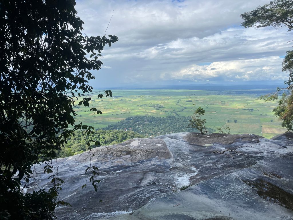
The best viewpoints in Udzungwa Mountains National Park are the rock shelf two thirds of the way up the Sanje Waterfall trail, the Mwanihana ridge at around 2,150 metres, the upper reaches of the Hidden Valleys circuit, and the base of the lower Sanje fall looking up. All are reached on guided walks from the Mang’ula gate, since the park has no interior roads. Udzungwa rises from the Kilombero Valley in south central Tanzania on an escarpment standing well over a kilometre above the plain.
Every view here has a price in hours. That is the trade, and it is why the ones you earn stay with people.
The Kilombero Valley Viewpoint on the Sanje Trail
The most reachable and, for most visitors, the best. About ninety minutes of climbing from the trailhead near Sanje village, the forest thins at a rock shelf and the whole floodplain opens below.
Sugar cane and rice run flat to the horizon, the Kilombero River threads through the middle, and on a clear morning the far escarpment stands up across the plain. It arrives as relief in a climb that is otherwise enclosed and repetitive, and most groups stay longer than the guide planned. The full Sanje Waterfall hike continues from here to the upper falls, so you do not have to choose between the view and the water.
The Base of the Lower Sanje Fall
Not a distant view but the most photographed sight in the park. A twenty minute detour off the main path, either on the ascent or coming down from the old hotel ruins, drops you at the foot of the largest of the three tiers.
Standing there and looking straight up at the full height of water coming off the escarpment is the frame most people take home. The pool at the bottom is warmer and larger than the one at the top, so this doubles as the better swimming spot on a hot day. Add roughly an hour to the trail timing and agree it at the start rather than halfway up.
The Mwanihana Ridge Above the Bamboo
The highest viewpoint most trekkers reach, at around 2,150 metres, two days into a 38 kilometre route from Sonjo village. The last stretch passes through montane forest, then bamboo glades that rattle in wind, then out onto bare rock and heather.
Southeast, the Kilombero lowlands spread towards Nyerere National Park. Northwest, forest runs unbroken to the horizon with no road, no village and no path visible in any direction. That second view is the one that matters, because it is the moment the size of this park stops being an abstraction.
Cloud sits on this altitude for a large part of the year, so a clear morning is luck rather than planning, and guides say so at the briefing rather than after.
The Hidden Valleys and the Moyer Plateau
The longest single day walk in the park, around seventeen kilometres over six to seven hours, climbing above 1,300 metres. What it opens up is not a single viewpoint but a landform nobody expects.
From the camp below, the skyline reads as one ridge. Climb it and that ridge turns out to be a step into a system of shallow valleys where streams flatten out and meander through open grassy ground favoured by elephants. Following those elephant trails down towards the Moyer River, with several crossings and a short detour to the Moyer waterfalls, is the reward. An armed ranger is required, since elephant and buffalo use the clearings.
Views from Sonjo and Prince Bernhard for Short Walkers
Both short trails stay under canopy and neither opens out in the way the longer routes do, which is worth knowing before you set expectations. The Prince Bernhard trail, about a kilometre from the headquarters, does give a view of Bokela mountain, treated locally as a deity, along with the falls themselves and reliable baboon and colobus sightings.
The Sonjo circuit at three kilometres reaches two cascades on a gentle climb of 120 metres. For visitors who cannot manage a long ascent, these deliver forest atmosphere rather than panorama, and the honest recommendation is to accept that rather than attempt Sanje unprepared.
Looking at the Park from Outside It
Some of the best views of these mountains are not inside the boundary at all. The drive south from Kidatu runs with the escarpment on your right for half an hour, a wall of forested cliff standing over flat cane country, and Sanje Waterfall is visible from the road as you pass through Sanje village.
The camp on the park boundary looks out over the forest canopy, with hornbills flying in at sunset. Udzungwa Falls Lodge, on the slopes above Msolwa Ujamaa, overlooks the Kilombero Valley from a distance. The flat trail at Magombera, below the mountains, gives views of the range from the plain looking up.
Comparing the Main Udzungwa Viewpoints
What You Are Actually Looking At
Knowing the geography makes the view land harder. The flat ground below is the Kilombero Valley, and the river running through it joins the Great Ruaha to form the Rufiji, which reaches the Indian Ocean well to the east. Water off the slopes you are standing on feeds all of it.
The cane fields belong to a large sugar operation centred on Kidatu, where there is also a hydroelectric station driven by the same catchment. Southeast beyond the plain lies Nyerere National Park. Behind you, northwest, the plateau rolls into forest that has held its ground for roughly thirty million years and still has no road through it. The view is not scenery so much as a working diagram of why this range matters.
Best Time of Day and Year for Clear Views
Early morning in the dry season, without much argument. Haze accumulates off the valley through the day and cloud gathers on the high ground by late morning, so an eight o’clock start beats a ten o’clock one by more than the two hours suggest.
Reaching a Viewpoint With Limited Fitness
Not everyone can climb for ninety minutes, and this park has fewer soft options than most. Worth saying plainly rather than leaving people to find out on the trail.
The realistic route is to walk as far up the Sanje trail as suits you and turn back, which is a normal decision here rather than a failure. Guides adjust readily and carry radio contact with the headquarters. Failing that, the best distant views of the range come from outside it: the drive south from Kidatu, the grounds of the camp on the boundary looking over the canopy, or the flat five kilometre trail at Magombera below the mountains, which gives the escarpment from the plain with no climbing at all.
Getting to the Viewpoint Trailheads
All walking starts with registration at the headquarters at Mang’ula, on the road between Mikumi town and Ifakara, where fees are paid and a guide assigned. The Sanje trailhead lies a few kilometres north near Sanje village, reached by tuk tuk. Sonjo village, serving the Mwanihana route, is a short transfer beyond. The Hidden Valleys circuit is usually walked from the camp end, which puts more shade over the ascent.
Mang’ula is five to six hours from Dar es Salaam via Chalinze, Morogoro and the highway through Mikumi National Park, and around 60 kilometres from Mikumi itself. Iringa lies two to three hours southwest.
Frequently Asked Questions About Udzungwa Viewpoints
What does it cost to reach the viewpoints?
Non resident adults pay a conservation fee of 30 US dollars per person for 24 hours, roughly 35.40 with value added tax, covering any day trails walked in that window. A compulsory guide adds around 20 dollars per day, charged per guide rather than per person, and an armed ranger a similar amount on routes such as Hidden Valleys. The multi day Mwanihana trek runs 400 to 500 dollars per person all in.
Which viewpoint is easiest to reach?
The rock shelf on the Sanje trail, about ninety minutes of climbing. You do not have to continue to the waterfall if the group has had enough, though almost everyone does. The short Sonjo and Prince Bernhard trails stay under canopy and do not open out.
Can you see the Indian Ocean from Udzungwa?
It is claimed locally from the highest ground on exceptionally clear days, and it is not something to plan around. What you will reliably see from the ridges is the Kilombero Valley running southeast towards Nyerere National Park, and unbroken forest inland in the other direction.
Are the high viewpoints worth the effort?
For walkers, yes. For anyone hoping for a guaranteed panorama, be cautious: cloud sits on the Mwanihana ridge for much of the year and a two day trek can end in mist. Guides are honest about this at the briefing, and the habitat variety on the way up is worth the walk regardless of what the summit shows you.
Do I need a guide to reach a viewpoint?
Yes. Every trail in the park requires a licensed guide with no self guided option anywhere, and the higher routes also require an armed ranger. Guides are assigned at the headquarters when you register, though multi day treks need arranging in advance.
What is the best viewpoint for photography?
The base of the lower Sanje fall for the single strongest image, and the Sanje rock shelf for the wide valley frame. Both want early morning light. A mid range zoom suits the valley better than an ultra wide, which flattens the escarpment out of the picture.
Booking Your Udzungwa Trip
The safari companies and tour operators listed on this website put trips like this together for a living and know which camps, guides and routes actually deliver. We are an independent guide to Udzungwa; we do not book or sell tours ourselves.
When you are ready, arrange your safari, tour or holiday with one of the recognised operators listed here. Tell them your dates and what matters most, and a real person, not a form, will handle the itinerary, park bookings and logistics for you.