Viewpoint Hikes in Udzungwa National Park
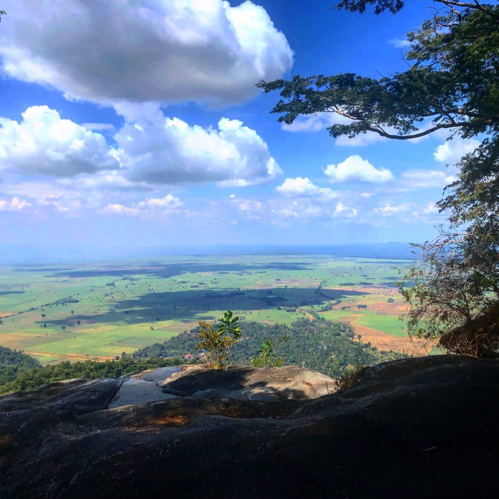
Viewpoint hikes in Udzungwa Mountains National Park are graded by effort rather than destination, from a ninety minute climb to the rock shelf on the Sanje trail to a three day trek reaching the Mwanihana ridge at around 2,150 metres. All start with a guide from the Mang’ula gate, since the park has no interior roads. Udzungwa rises in south central Tanzania on an escarpment standing well over a kilometre above the Kilombero Valley.
Choose by the hours you have rather than by the photograph you have seen. The best view here is the one you can reach before the haze arrives.
Ninety Minutes: The Sanje Rock Shelf
The obvious first choice, and for most visitors the only one they need. Around ninety minutes of climbing from the trailhead near Sanje village brings you to a rock shelf where the forest thins and the whole floodplain opens below.
You do not have to continue to the waterfall if the group has had enough, though almost everyone does since the full Sanje Waterfall hike runs four to six hours and the falls sit above. As a standalone viewpoint objective, turning back here makes a three hour morning that delivers the park’s signature view without the steepest section of trail.
Half a Day: The Njokamoni Climb
Four to five hours over roughly six and a half kilometres, gaining similar height to Sanje with the climb spread more evenly. This is not a viewpoint trail in the conventional sense, since it stays largely under canopy, and it earns a place here for a different reason.
The gaps and stream crossings along it open small framed views rather than panoramas, and almost nobody walks it, so you are looking at them alone. For anyone who finds the idea of a viewpoint queue unappealing, this is the honest recommendation, with a waterfall and bathing pool at the top and the best odds in the park for the endemic Sanje mangabey along the way.
A Full Day: The Hidden Valleys Plateau
Seventeen kilometres over six to seven hours, climbing above 1,300 metres, and the only single day walk here that opens genuinely upland country.
The reward is not a single vista but a landform. What reads as one ridge from below turns out to be a step into shallow valleys where streams flatten and meander through open grassy ground used by elephants. An armed ranger is required, part of the descent crosses old fire damage where the path is easy to lose, and guides recommend starting from the camp end so more tree cover shades the ascent.
Two or Three Days: The Mwanihana Ridge
The highest viewpoint most trekkers reach, at around 2,150 metres on a 38 kilometre route from Sonjo village. The final stretch passes through montane forest, then bamboo glades that rattle in wind, then bare rock and heather.
Southeast the Kilombero lowlands run towards Nyerere National Park. Northwest, forest stretches unbroken to the horizon with no road, village or path visible in any direction, and that second view is the one that lands. Cloud sits on this altitude for much of the year, which guides say at the briefing rather than afterwards, so treat a clear morning as luck.
The Viewpoint That Needs No Walking
Worth stating plainly, because not every visitor can climb. Some of the best views of this range are from outside it. The drive south from Kidatu runs with the escarpment on your right for half an hour, a wall of forested cliff over flat cane country, with Sanje Waterfall visible from the road at Sanje village.
The camp on the park boundary looks out over the forest canopy, and hornbills fly in along it at sunset. Below the mountains, the flat five kilometre trail at Magombera gives the escarpment from the plain looking up, on entirely level ground. None of these ask anything of your knees.
Reading the View From the Escarpment
Knowing what you are looking at makes the climb land harder. The flat ground below is the Kilombero Valley, and the river crossing it joins the Great Ruaha to form the Rufiji, which reaches the Indian Ocean far to the east. Water off the slope you are standing on feeds all of it.
The cane belongs to a large sugar operation centred on Kidatu, where a hydroelectric station runs on the same catchment. Rice fills the rest. Behind you the plateau rolls into forest that has held its ground for roughly thirty million years. The view is less scenery than a working diagram of why this range is protected.
Grading the Viewpoint Hikes by Effort
Timing a Viewpoint Hike for the Light
Morning, in every case and every season. Haze builds off the valley through the day, and cloud gathers on the high ground by late morning, so an eight o’clock start beats a ten o’clock one by considerably more than the two hours suggest.
Photographers should carry a mid range zoom rather than an ultra wide, which flattens the escarpment into nothing, and a cloth for lenses that fog on stepping out of forest into open air. On the high ridges, mist tearing through bamboo is both more likely and more interesting than a clear panorama, so photograph the weather rather than waiting it out.
Turning Back Is a Normal Decision
Worth saying because people treat it as failure. Guides carry radio contact with the headquarters and adjust routes constantly, and groups shorten walks here every week without anyone commenting.
On a viewpoint hike this matters more than on a waterfall walk, because the objective is a view that may not be there. If cloud has closed in by the time you reach the rock shelf on the Sanje trail, continuing another two hours to the falls is still worthwhile, while pushing on to a summit that is plainly socked in is not. Say early if the group has had enough rather than at hour five, and the day usually ends better for it.
Best Season for Viewpoint Hikes
June through October gives firm trails and the highest chance of a clear morning. The wet months bring low cloud and slippery ground, which affects the high routes far more than the short ones.
What Limits the View on Any Given Day
Three things, and none of them are within anyone’s control. Valley haze is the first, building off cultivated flat ground through the morning and thickening as the day warms. Cloud is the second, forming on the escarpment from mid morning and sitting on the higher ground for much of the year.
Season is the third and the only one you can plan around. Between March and May low cloud is the norm rather than the exception, which is one reason the high routes are often suspended in those months. Guides read the morning before setting off and will say if the ridge looks hopeless, which is a conversation worth having rather than talking them out of.
Getting to the Viewpoint Trailheads
Register at the headquarters at Mang’ula on the road between Mikumi town and Ifakara, where fees are paid and a guide assigned. The Sanje trailhead is a few kilometres north near Sanje village, reached by tuk tuk. Sonjo village serves the Mwanihana route, and Hidden Valleys is usually entered from the camp end.
Mang’ula is five to six hours from Dar es Salaam via Chalinze, Morogoro and the highway through Mikumi National Park, and around 60 kilometres from Mikumi. Iringa lies two to three hours southwest.
Frequently Asked Questions About Viewpoint Hikes
What do viewpoint hikes cost?
The conservation fee of 30 US dollars per person for 24 hours for non resident adults, roughly 35.40 with value added tax, covers any day trail. A compulsory guide adds around 20 dollars per day charged per guide rather than per head, and an armed ranger a similar amount on the Hidden Valleys route. The multi day Mwanihana trek to the ridge runs 400 to 500 dollars per person all in.
Which viewpoint needs the least climbing?
The Sanje rock shelf at about ninety minutes, and you can turn back there rather than continuing to the falls. For no climbing at all, the views from the road south of Kidatu, from the camp grounds on the boundary, and from the flat trail at Magombera are all genuinely good.
Will I definitely get a view?
From the Sanje shelf in the dry season, very probably, if you go early. From the high ridges, no. Cloud sits on the Mwanihana altitude for much of the year and a two or three day trek can end in mist. Guides are honest about this before you book rather than after.
Can you see the Indian Ocean?
It is claimed locally from the highest ground on exceptionally clear days and is not something to plan around. What you will reliably see is the Kilombero Valley running southeast towards Nyerere National Park, and unbroken forest inland.
Do I need a guide just for a viewpoint?
Yes. Every trail in the park requires a licensed guide with no self guided option anywhere, no matter how short the walk. Guides are assigned at the headquarters when you register, and day walks need no advance booking.
What is the best time of day?
Early morning without much competition. Valley haze thickens as the day goes on and cloud gathers on the plateau by late morning, so guides push for an eight o’clock start and earlier is better still.
Booking Your Udzungwa Trip
The safari companies and tour operators listed on this website put trips like this together for a living and know which camps, guides and routes actually deliver. We are an independent guide to Udzungwa; we do not book or sell tours ourselves.
When you are ready, arrange your safari, tour or holiday with one of the recognised operators listed here. Tell them your dates and what matters most, and a real person, not a form, will handle the itinerary, park bookings and logistics for you.