Plateau Viewpoints
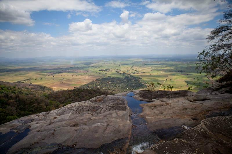
The plateau viewpoints in Udzungwa Mountains National Park are reached on guided hikes ranging from a four hour waterfall climb to multi day treks onto the high ground, and all of them look out over the Kilombero Valley. Trails start at the headquarters at Mang’ula and a licensed guide is compulsory on every route. Udzungwa is a rainforest park in south central Tanzania with no interior roads, so every viewpoint here is earned on foot.
The escarpment rises fifteen hundred metres or more above the valley floor in a series of cliffs, which is why even a modest climb here delivers a view that would need a whole day’s driving elsewhere.
Plateau Viewpoint Hiking Safaris in Udzungwa Mountains National Park
A viewpoint hiking safari in this park means choosing your altitude and paying for it in hours. Four levels are available, roughly speaking. The Sanje trail gets you a valley overlook in a morning. The Hidden Valleys circuit takes a full day and puts you above thirteen hundred metres. The Mwanihana route reaches the ridge over two or three days. Luhombero, at around 2,576 metres, requires most of a week.
Each one shows a different thing. Low viewpoints frame the farmland and the river. High ones show you the forest itself, rolling away northwest with no road, no village and no path visible in any direction.
The Kilombero Valley Viewpoint on the Sanje Waterfall Trail
The most accessible viewpoint in the park sits about two thirds of the way up the Sanje Waterfall trail, where the forest thins at a rock shelf and the whole Kilombero floodplain opens below. Sugar cane and rice run flat to the horizon, the Kilombero River threads through the middle of it, and on a clear morning the far escarpment stands up across the plain.
Getting there takes roughly ninety minutes of climbing from the trailhead near Sanje village. The full trail runs four to six hours return with about 450 metres of gain, so the viewpoint arrives as relief partway through a climb that is otherwise enclosed and repetitive. Most groups stop here longer than the guide planned.
Hidden Valleys Trekking Route to the Moyer Plateau
The Hidden Valleys trail, also called the Campsite 3 circuit, is the longest single day hike in the park at around seventeen kilometres and six to seven hours, climbing to about 1,300 metres. It is also the one that changes how people think about this range.
What looks like a simple ridge from the camp below turns out to be only a step into a system of shallow valleys behind it, where streams flatten out and meander through open grassy ground. Elephants favour those clearings. You follow their trails down towards the Moyer River, cross it several times, and there is a short detour to the Moyer waterfalls if the group has the legs for it.
Part of the descent passes through ground burnt by fire some years back, where the canopy has gone and low vegetation has taken over, riddled with elephant tracks. The correct path is easy to lose there, which is one reason a ranger walks this route. The circuit finishes near Campsite 3 by the road.
Mwanihana Ridge Viewpoints Above the Bamboo Zone
The highest viewpoint most trekkers reach sits on the Mwanihana ridge at around 2,150 metres, two days into a 38 kilometre route from Sonjo village. The last stretch passes through montane forest, then bamboo glades that rattle in wind, then out onto bare rock and heather.
Southeast, the Kilombero lowlands spread towards Nyerere National Park. Northwest, forest runs unbroken to the horizon. Cloud sits on this altitude for a large part of the year, so a clear morning is luck rather than planning, and guides say so at the briefing rather than after.
Grassy Plateau Corridors and Elephant Country
The open ground on the plateau is not scenery alone. Those grassy corridors, flanked on both sides by tall forest, are the routes elephant and buffalo use to move through the range. Tracks, dung and broken branches are constant. The animals themselves turn up often enough that TANAPA requires an armed ranger on every trail that reaches this altitude.
Walking here is quieter than the closed forest below and considerably more exposed. Rangers set the spacing and decide when to hold position, and that is not a discussion. In practice most groups spend the plateau sections reading sign rather than seeing animals, which is its own kind of interesting.
What You Can Actually See from the Udzungwa Plateau
You will hear claims that the Indian Ocean is visible from the high ground on exceptional days. Treat that as local folklore unless you see it for yourself.
Photography at the Udzungwa Plateau Viewpoints
Wide light and long distance make these the easiest photographs in a park that is otherwise hard to shoot, since forest interiors are dim and contrasty. The valley overlooks want early morning, before haze thickens, and a mid range zoom rather than an ultra wide, which flattens the escarpment into nothing.
On the high ridges, mist is as much subject as obstacle. Cloud tearing through bamboo is worth more than a clear panorama, and it is far more likely. Carry a cloth, because humidity fogs lenses within a minute of stepping out of the forest into open air.
How Hard the Viewpoint Hikes Are
The gradient is the same story on every route: sustained rather than technical. No scrambling, no exposure, plenty of uneven ground and roots. Sanje’s viewpoint is within reach of anyone who walks regularly. Hidden Valleys asks for a full day of fitness and punishes tired knees on the descent. Mwanihana needs consecutive days on foot and a tolerance for camping.
Trekking poles help everywhere. Boots with real tread matter more after rain than in the dry months, when the steep sections firm up.
Best Time for Clear Plateau Views
June through October gives the highest chance of a clear morning and the firmest trails. From November to May the forest is greener and the waterfalls run harder, with cloud sitting lower on the plateau and views arriving less reliably. The long rains from March to May make the higher circuits genuinely difficult.
Getting to the Viewpoint Trailheads
All hikes begin with registration at the park headquarters at Mang’ula, on the road between Mikumi town and Ifakara, where fees are paid and a guide is assigned. The Sanje trailhead is a few kilometres north and reached by tuk tuk or vehicle. Sonjo village, where Mwanihana treks start, lies a short transfer beyond that. The Hidden Valleys circuit is usually walked from the camp end, which puts more shade over the ascent.
Mang’ula is five to six hours from Dar es Salaam via Chalinze, Morogoro and the highway through Mikumi National Park. From Mikumi it is around 65 kilometres, roughly ninety minutes. Iringa lies two to three hours southwest. The TAZARA train stops at Mang’ula station and Ifakara buses pass the gate.
Frequently Asked Questions About Udzungwa Viewpoints
How much does it cost to hike to the Udzungwa viewpoints?
Non resident adults pay a conservation fee of 30 US dollars per person for 24 hours, roughly 35.40 with value added tax, covering any day trails walked in that window. A compulsory guide adds around 20 dollars per day, charged per guide rather than per person. Routes needing an armed ranger add a similar daily fee. The multi day Mwanihana trek to the high ridge runs 400 to 500 dollars per person all in.
Which viewpoint is easiest to reach?
The Kilombero Valley overlook on the Sanje trail, about ninety minutes of climbing from the trailhead. You do not have to continue to the waterfall if the group has had enough, though most people do. The shorter Sonjo and Prince Bernhard walks stay under canopy and do not open out.
Can you see the Indian Ocean from the Udzungwa plateau?
It is claimed locally on exceptionally clear days from the highest ground, and it is not something to plan around. What you will reliably see from the ridges is the Kilombero Valley running southeast towards Nyerere National Park, and unbroken forest in the other direction.
How long is the Hidden Valleys trail?
Around seventeen kilometres, taking six to seven hours and reaching about 1,300 metres. It is the longest single day walk in the park. An armed ranger is required because elephant and buffalo use the grassy clearings, and sections of burnt ground make the path easy to lose.
Do I need a guide for the viewpoint trails?
Yes. Every trail in Udzungwa requires a licensed park guide with no self guided option anywhere, and the higher routes also require an armed ranger. Guides are assigned at the headquarters when you register, though multi day treks need arranging in advance.
What time of day gives the best views?
Early morning, without much competition. Haze builds off the valley through the day and cloud tends to gather on the high ground by late morning. Guides usually push for an eight o’clock start, partly for the light and partly because the lower forest is unpleasant in midday heat.
Booking Your Udzungwa Trip
The safari companies and tour operators listed on this website put trips like this together for a living and know which camps, guides and routes actually deliver. We are an independent guide to Udzungwa; we do not book or sell tours ourselves.
When you are ready, arrange your safari, tour or holiday with one of the recognised operators listed here. Tell them your dates and what matters most, and a real person, not a form, will handle the itinerary, park bookings and logistics for you.