What Are the Main Ecosystems of Udzungwa?
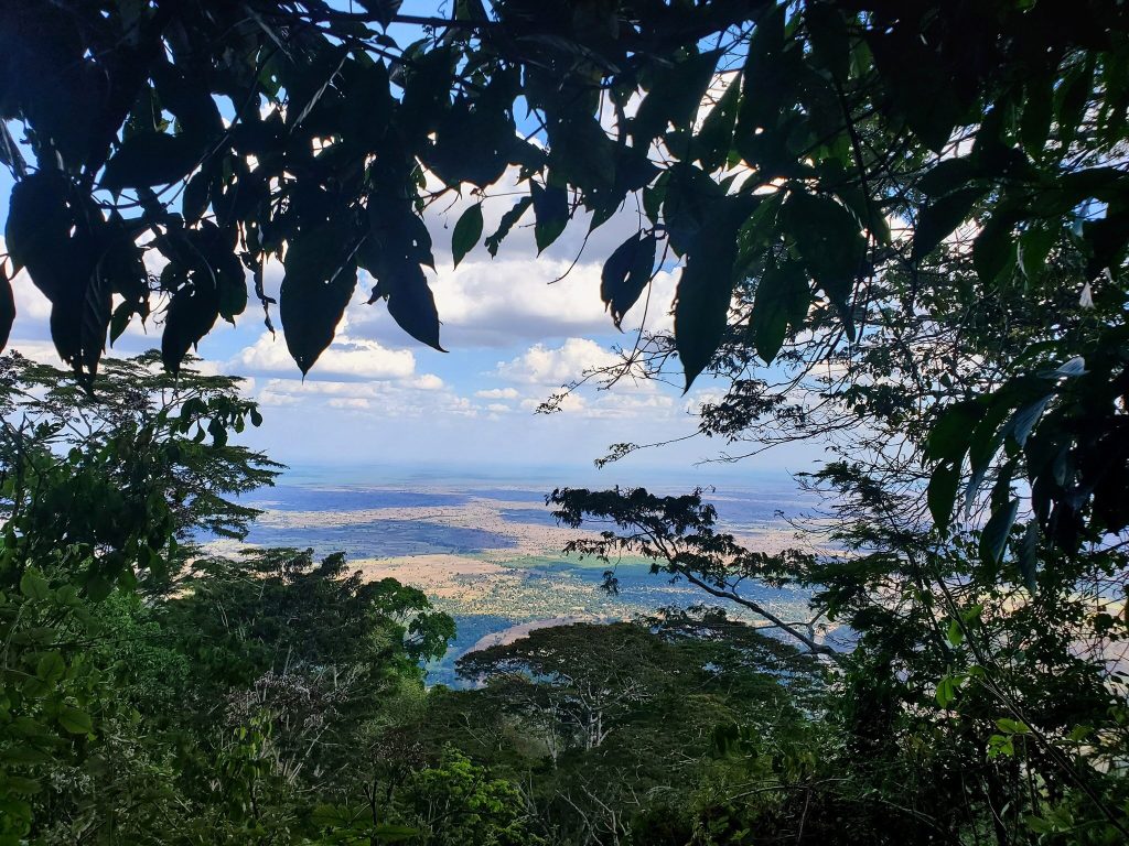
Udzungwa Mountains National Park holds six main ecosystems stacked by altitude: miombo woodland, lowland tropical rainforest, submontane forest, montane forest, bamboo, and highland grassland and steppe, with riverine forest threading through all of them. Guided walks and treks from the Mang’ula gate cross several in a single day. The park runs from around 250 metres to 2,576 in south central Tanzania, and its forest is unbroken across that whole range.
That continuity is the unusual part. Most African mountains keep forest only in patches on the high ground, with the lowland belt long since cleared.
Miombo Woodland at the Foot of the Mountains
The lowest and driest band is miombo, the open brachystegia woodland that covers much of southern Africa and fringes the park where forest meets farmland. Trees stand widely spaced, light comes straight through and grass grows underfoot.
It looks nothing like the rainforest above it. The Mwanihana trekking route begins in this band and the longer Sonjo trail passes through it. Butterflies gather at damp patches here in numbers through the wetter months, and yellow baboons, bushbuck and duiker use it. Certain rarer primates drop out of denser forest to feed in the miombo for part of the day, which is why guides do not hurry through it.
Lowland Tropical Rainforest Above the Valley
From roughly 300 metres upward, canopy closes over the trail and the character changes completely. Buttressed trunks, thick understorey, light arriving in patches, ferns crowding the stream banks.
This is where most visitors spend their time, since the short trails and the lower half of the Sanje Waterfall hike all sit in this band. It is also the preferred habitat of the Udzungwa red colobus, the park’s most visible endemic, along with Angolan black and white colobus and blue monkeys. Being low altitude makes it the most threatened ecosystem here, because low ground is the ground people farm.
Submontane Forest and the Mangabey Zone
Between about 800 and 1,400 metres the forest shifts again. Trees run tall and straight, moss appears on trunks, and epiphytes and orchids become common overhead.
The Sanje mangabey, one of the two primates found only in these mountains, ranges through this band, foraging on the ground as much as in the canopy. The Njokamoni trail and the middle sections of the Hidden Valleys and Mwanihana routes cross it. Humidity remains high but the heat eases, which is when most walkers start enjoying themselves rather than enduring.
Montane Forest on the Upper Slopes
Above roughly 1,400 metres the trees shorten, mist becomes near constant and the ground softens with leaf litter and moss. This is cloud forest in everything but name, and it holds the species birders come for.
The Udzungwa forest partridge lives in this band, recorded in the Ndundulu and Luhombero forest between about 1,350 and 2,060 metres. So do Eastern Arc specialists including the rufous winged sunbird, Iringa akalat and yellow throated mountain greenbul. The kipunji, described from Ndundulu Forest in 2004, is a high altitude animal too. Reaching any of this means a multi day trek rather than a day walk.
Bamboo and Heather Near the Summits
The last band before open rock is the strangest. Glades of bamboo rustle and creak in wind just below the summit of Mwanihana at around 2,150 metres, and above them heather and bare rock take over.
The transition happens fast, over a few hundred metres of climbing, and the temperature drops with it. Nights at this altitude fall towards nine degrees between June and September. Very few visitors see this ecosystem, since it exists only at the top of the longest routes, which is precisely why trekkers talk about it afterwards.
Highland Grassland and Steppe on the Plateau
The western part of the park carries highland grassland rather than forest, and open grassy corridors run through the high ground flanked on both sides by tall trees. These are not gaps in the forest so much as a habitat in their own right.
Elephant and buffalo use them as movement routes, which is why TANAPA requires an armed ranger on every trail reaching this altitude. On the Hidden Valleys circuit the streams flatten out and meander through these clearings, and the terrain reads more like upland Britain than tropical Africa until you notice the elephant dung.
Riverine Forest and the Park’s Waterways
Cutting across every altitude band, rivers and streams carry their own community. Ferns line the banks, butterflies gather on damp sand at crossings, and kingfishers work the lower reaches.
The Njokamoni, Moyer and Lumemo rivers all rise here, and water off these slopes feeds the Kilombero, which joins the Great Ruaha to form the Rufiji. The range functions as a water tower for a large part of southern Tanzania, irrigating the valley below, supporting fisheries and driving hydropower at Kidatu. Canopy holds the rain and releases it slowly, which prevents flooding in the wet months and keeps rivers running through the dry ones.
The Kilombero Wetlands Below the Escarpment
Outside the park boundary but part of the same system, the Kilombero floodplain spreads flat below the mountains under rice, sugar cane and seasonal marsh. The wetlands along the Mang’ula road add herons, kingfishers and cisticolas to any bird list, including two cisticola species restricted to this valley.
Lowland forest patches survive here in fragments. Magombera, at the eastern foot of the range, is the most important, holding one of the healthiest red colobus populations outside the park along with rare trees, on flat ground with a five kilometre trail.
How the Ecosystems Fit Together
Around 2,500 plant species have been recorded across these bands, roughly a quarter of them found only in the Eastern Arc, alongside some 400 bird species and twelve primates.
Why the Ecosystems Are Stacked So Tightly
Rainfall does most of the sorting. Moist air off the Indian Ocean rises against the escarpment and drops up to two or three thousand millimetres a year on the southeastern slopes, while the northwestern side sits in a rain shadow at around six hundred. Wet flank, dry flank, and a steep gradient between them.
Add altitude to that and the bands compress. Temperature falls as you climb, humidity shifts, and each combination supports a different community, so the change that would take hundreds of kilometres of latitude elsewhere happens over a couple of hours of walking here. The mountains have also held this arrangement for something like thirty million years, which is why so many species have had time to specialise in one band and no other.
Best Time to See the Different Ecosystems
The low bands are accessible year round. The montane and bamboo zones effectively need the dry season, since the routes reaching them become impractical in the long rains.
Getting to Udzungwa to Walk Through the Ecosystems
Register at the headquarters at Mang’ula on the road between Mikumi town and Ifakara. Dar es Salaam is five to six hours away via Chalinze, Morogoro and the highway through Mikumi National Park, with graded dirt for the last 24 kilometres from Kidatu. Mikumi is around 60 kilometres north and Iringa two to three hours southwest.
To cross the most bands in one trip, the 38 kilometre Mwanihana trek over three days is the route, running from miombo at the bottom to heather at the top. For a single day, the Hidden Valleys circuit at seventeen kilometres reaches above 1,300 metres.
Frequently Asked Questions About Udzungwa’s Ecosystems
What does it cost to walk through these habitats?
The park conservation fee is 30 US dollars per person for 24 hours for non resident adults, about 35.40 with value added tax, plus a compulsory guide at roughly 20 dollars per day charged per guide rather than per head. Reaching the montane and bamboo bands means a multi day trek at 400 to 500 dollars per person for the Mwanihana route, which covers porters, cook, ranger, equipment and all fees.
How many ecosystems does the park contain?
Six main ones: miombo woodland, lowland tropical rainforest, submontane forest, montane forest, bamboo, and highland grassland and steppe, with riverine forest running through all of them. Sources sometimes group these differently, but the altitude sequence is consistent.
Which ecosystem holds the most endemic species?
The montane band, which carries the Eastern Arc bird specialists, the kipunji and much of the endemic plant list. The lowland forest holds the most visible endemic, the red colobus, and is the most threatened band because it is the easiest to clear for farming.
Can I see more than one ecosystem in a day?
Yes. The Sanje trail crosses miombo edge, lowland forest and the bottom of the submontane band across four to six hours. The Hidden Valleys circuit goes further, reaching above 1,300 metres in six to seven hours. Getting into bamboo needs an overnight.
Why is the unbroken altitude gradient important?
Because species can move up and down it with the seasons instead of being trapped in isolated fragments. Most tropical African mountains have lost their lowland forest, leaving only high patches. Udzungwa keeps the whole sequence, which is why it is treated as one of the most important forest blocks on the continent.
Are the ecosystems under threat?
The lowland bands most of all. Clearing for farmland, logging, charcoal production, hunting and fire press on the boundary, and several lowland forest patches in the Kilombero Valley outside the park have already been lost. Buffer zone programmes, revenue sharing with villages and long term monitoring at Mang’ula are the main responses.
Booking Your Udzungwa Trip
The safari companies and tour operators listed on this website put trips like this together for a living and know which camps, guides and routes actually deliver. We are an independent guide to Udzungwa; we do not book or sell tours ourselves.
When you are ready, arrange your safari, tour or holiday with one of the recognised operators listed here. Tell them your dates and what matters most, and a real person, not a form, will handle the itinerary, park bookings and logistics for you.