River Crossings in Udzungwa National Park
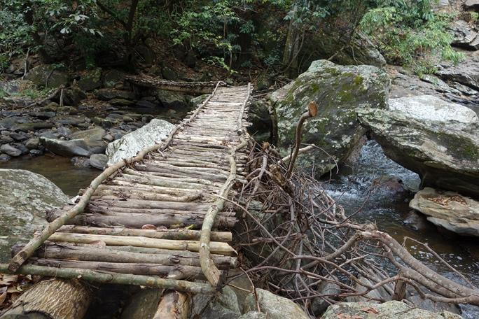
River crossings are a regular feature of hiking in Udzungwa Mountains National Park, with log bridges on the Sanje trail, several crossings of the Njokamoni river, and multiple fords of the Moyer on the Hidden Valleys circuit. Levels rise sharply during the rains, and guides make the call on whether a crossing is safe. Udzungwa sits in south central Tanzania, and water off these slopes feeds the Kilombero and Rufiji river systems.
Nobody books a hike for the crossings. They are, all the same, where a good deal of the wildlife and most of the falls happen.
Why This Park Has So Many Streams
Rainfall and geology. Moist air off the Indian Ocean rises against the escarpment and drops up to two or three thousand millimetres a year on the southeastern slopes, while the northwestern side sits in a rain shadow at around six hundred.
Forest canopy holds that water and releases it slowly rather than letting it run straight off, which prevents flooding in the wet months and keeps streams running through the dry ones. The Njokamoni, Moyer and Lumemo rivers all rise here. The range functions as a water tower for a large part of southern Tanzania, irrigating the Kilombero Valley, supporting fisheries and driving hydropower at Kidatu.
Crossings on the Sanje Waterfall Trail
The Sanje Waterfall hike includes a couple of stream crossings on logs in the first section, before the climb steepens. In the dry months they are straightforward. After rain they demand attention, since wet timber over moving water is the least forgiving surface on the trail.
Guides cross first and position themselves to steady people coming over. Take the offered hand rather than declining it out of pride, which is a mistake made regularly and occasionally expensively. Trekking poles help considerably here, giving a third point of contact where a log gives only one foot at a time.
The Njokamoni River Crossings
The Njokamoni trail follows its river upstream over four to five hours, crossing more than once, and the balance work on wet stone is what makes this route feel different from Sanje even though the length and height gain are similar.
The same stream supplies water to the forest camp on the park boundary, a detail that makes the geography click once you are back down. Crossings here are on rock rather than logs for the most part, which is more secure underfoot and slower to negotiate. There is a waterfall and bathing pool at the top, so most groups end the climb by getting into the water deliberately rather than accidentally.
The Moyer River on the Hidden Valleys Circuit
The most crossings of any route in the park. The Hidden Valleys circuit runs around seventeen kilometres over six to seven hours, climbing above 1,300 metres, and the descent follows elephant trails down to the Moyer River with several crossings before the escarpment drops away.
A short detour reaches the Moyer waterfalls. An armed ranger accompanies every party since elephant and buffalo use the grassy clearings up there, and part of the descent passes through ground burnt years ago where canopy has gone and the path is easy to lose. This is the trail where footwear with real grip stops being advice and becomes the difference between a good day and a bad one.
Wildlife at the Crossings
Water draws everything, which is why guides slow down at streams rather than hurrying across. Butterflies gather at damp sand in dozens of species, particularly through the wetter months, sometimes lifting in clouds as you pass. Mud puddling groups sit tight until disturbed, so walking the first ten metres slowly is worth doing deliberately.
Kingfishers work the lower reaches. Duikers come down to drink and freeze rather than bolting if you stop moving. Sengis rustle through the leaf litter along the banks. On the higher routes, elephant tracks in the mud beside a crossing are often the clearest sign you will see all day of animals you never actually meet.
How Water Levels Change Through the Year
Considerably, and it affects everything. From June to October crossings are low and straightforward across all the trails. From November the short rains raise them intermittently, and during the long rains from March to May they rise properly.
That is the main reason several trails become impractical in those months and many operators suspend multi day treks entirely. It also changes the waterfalls: swimming pools that are gentle in September become churning in April, and guides call swimming off outright when the current is unsafe. Ask about conditions at the headquarters when you register rather than assuming, since the answer moves week to week.
Crossing Safely
Footwear and Kit for Wet Trails
Boots with real tread matter more on these routes than anywhere else in the park. Trainers with worn soles are how people fall, and the descent after a crossing punishes tired legs on wet stone.
Some walkers carry sandals or water shoes for the crossings themselves and change back after, which works on Njokamoni where crossings are frequent and less so on Sanje where there are only a couple. Dry bags for anything electronic are sensible, since spray and slips both happen. Trekking poles earn their weight, and on multi day treks the crew crosses first and helps loads over.
Crossings on the Multi Day Routes
Trekking parties handle water differently, since the crew crosses first and helps loads over before anyone else moves. On the 38 kilometre Mwanihana route the trail runs alongside sparkling mountain streams for much of its length, with butterflies working the dappled light at every gap.
The five day Lumemo trail begins beyond Ifakara on the Lumemo River itself, so the water is the starting point rather than an obstacle along the way. Camps on both routes are chosen around water sources rather than around distance, which is why daily mileage varies more than a schedule suggests. Washing in a mountain stream at the end of eight hours of walking is bracing and, by the second evening, something people look forward to.
Best Time for Trails With River Crossings
June through October, without much argument, because low water changes these routes from technical to straightforward.
The Rivers Beyond the Park Boundary
The streams you cross on these trails do not stop at the gate. Below the escarpment they join the Kilombero, which runs southeast across the floodplain before meeting the Great Ruaha to form the Rufiji and eventually reaching the Indian Ocean.
That system irrigates the sugar and rice country you drive through on the way in, supports freshwater fisheries and drives the hydroelectric station at Kidatu. The forest canopy above regulates all of it, holding rain and releasing it slowly. Standing on a log over a stream on the Sanje trail, it is worth knowing that the water under your boots is on its way to a power station and a rice field before it reaches the sea.
Getting to the Trails With River Crossings
Register at the headquarters at Mang’ula on the road between Mikumi town and Ifakara, where fees are paid and a guide assigned. Njokamoni starts there and finishes on the road below the forest camp. The Sanje trailhead lies a few kilometres north, and Hidden Valleys is usually entered from the camp end.
Mang’ula is five to six hours from Dar es Salaam via Chalinze, Morogoro and the highway through Mikumi National Park, and around 60 kilometres from Mikumi itself. The final 24 kilometres from Kidatu are graded dirt, which itself slows after heavy rain.
Frequently Asked Questions About River Crossings
Do crossings affect what a hike costs?
No. The park conservation fee is 30 US dollars per person for 24 hours for non resident adults, roughly 35.40 with value added tax, whichever trail you walk, plus a compulsory guide at around 20 dollars per day charged per guide rather than per head. Trails with more crossings simply take longer rather than costing more.
How deep are the crossings?
Ankle to knee deep on most trails in the dry season, with log bridges over the deeper points on the Sanje route. During the long rains from March to May they rise well above that, which is when guides start refusing particular routes rather than particular crossings.
Will I get my feet wet?
On Njokamoni and Hidden Valleys, almost certainly. On Sanje, probably not in the dry season since the main crossings are bridged. Carry spare socks regardless, because wet feet over a long descent are the most preventable discomfort on any of these walks.
Are the crossings dangerous?
Not in the dry season with a guide, when they are shallow and slow. In the rains they become the main hazard on several trails, which is why routes get suspended rather than attempted carefully. The guide’s judgement on this is not open to negotiation and should not be.
Can children manage the crossings?
On the short trails, yes. The Sonjo circuit and Prince Bernhard have minor crossings that children of six or so handle with a hand held. The multiple fords on Njokamoni and Hidden Valleys are better suited to older children and adults, particularly after rain.
Is the water safe to drink?
Not untreated. On multi day treks the crew draws stream water and treats it, which is the normal arrangement. On day walks carry two to three litres, since there is no safe refill point on any trail and the lower forest is hot enough that people drink faster than they expect.
Booking Your Udzungwa Trip
The safari companies and tour operators listed on this website put trips like this together for a living and know which camps, guides and routes actually deliver. We are an independent guide to Udzungwa; we do not book or sell tours ourselves.
When you are ready, arrange your safari, tour or holiday with one of the recognised operators listed here. Tell them your dates and what matters most, and a real person, not a form, will handle the itinerary, park bookings and logistics for you.