Where Is Udzungwa Located?
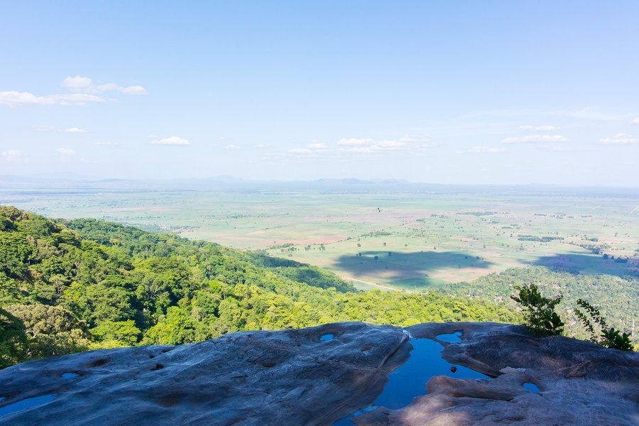
Udzungwa Mountains National Park is in south central Tanzania, straddling the Kilolo District of Iringa Region and the Kilombero District of Morogoro Region, roughly 350 to 380 kilometres west of Dar es Salaam. The park gate and headquarters sit at Mang’ula village, about 65 kilometres south of Mikumi National Park on the road towards Ifakara. It covers 1,990 square kilometres of the Eastern Arc chain, rising from the Kilombero Valley floor to peaks above 2,500 metres.
People get confused about this park’s location more than most, partly because it appears under two regions and partly because several villages along one road all claim to be the entrance.
Where Udzungwa Mountains National Park Sits in Tanzania
Coordinates put the park at roughly seven degrees forty eight minutes south, thirty six degrees forty one minutes east. On a map of Tanzania that places it well inland, south of the central corridor and firmly within what the tourism industry calls the southern circuit.
The nearest city of any size is Morogoro, about 158 kilometres away. Iringa lies two to three hours to the southwest and is the largest settlement in the mountains themselves. Dar es Salaam, the arrival point for nearly every visitor, is five to six hours by road to the east.
A Udzungwa safari fits naturally into a southern itinerary alongside Mikumi, Ruaha and Nyerere, and awkwardly into anything based on Arusha in the north.
The Regions and Districts the Park Covers
Administratively the park sits in two regions at once, which is why sources disagree about where it is. The larger share lies in the southern highland region of Iringa, in the Kilolo District, with the remainder in Morogoro Region’s Kilombero District. Some accounts put the split at roughly eighty and twenty percent.
In practice this matters little to visitors, since the gate, the headquarters and almost all the accommodation are on the Morogoro side at Mang’ula. It matters more when reading official documents, where the park may appear filed under either region depending on who compiled the list.
Udzungwa’s Place in the Eastern Arc Mountain Chain
The park protects part of the Udzungwa Mountains, the largest of the Eastern Arc ranges, which as a whole cover something like 16,000 square kilometres. The chain itself runs from the Taita Hills in southern Kenya down through Tanzania, a string of isolated fault bounded blocks of ancient Precambrian rock that have stood as highland islands for roughly thirty million years.
That isolation is why the range is sometimes called the Galapagos of Africa. It is recognised as one of the world’s biodiversity hotspots and as a World Wide Fund for Nature ecoregion of global importance.
The Kilombero Valley Below the Escarpment
The mountains rise steeply from the Kilombero Valley to their southeast in a series of sheer rock escarpments, and that valley is what you drive through on the way in. Sugar cane, rice and maize fill the flat ground, along with a large rubber plantation, and villages line the road.
Water off these slopes feeds the Kilombero River, which joins the Great Ruaha to form the Rufiji, so the range acts as a water tower for a large part of southern Tanzania. Irrigation in the valley, freshwater fisheries and hydropower downstream all depend on it. Kidatu, which you pass on the drive, has a hydroelectric station.
How Far Udzungwa Is from Other Southern Circuit Parks
Nyerere National Park lies to the southeast beyond the Kilombero plain, which is why the view from the high ridges runs in that direction. Ruaha sits west beyond Iringa. A southern circuit trip stringing Mikumi, Udzungwa and Nyerere together is the standard shape.
Mang’ula and the Villages Along the Park Boundary
Mang’ula is the reference point for everything. The park headquarters sit beside the road there, registration and fee payment happen at that office, and guides are assigned from it. A solar powered camp on the forest boundary and a handful of village guesthouses provide the only beds nearby.
North along the same road, Sanje village sits below the waterfall of the same name, and Sonjo village further on is where the Mwanihana trekking route begins. Kilombero and Kidatu lie back towards Mikumi. On the western side of the range, Udekwa village provides a separate and much less used point of access.
The Park’s Altitude Range and Terrain
Udzungwa runs from around 250 metres at its lowest to roughly 2,576 metres at Luhombero Peak, the highest point in the park and one of the highest in the Eastern Arc. Mwanihana, the second summit, stands near 2,150 metres.
Between those extremes the terrain is rolling hills, dissected plateau, narrow canyons, fern lined ravines and river gorges, with forest running unbroken up the whole gradient. That continuity is rare in African mountains and is the reason the park matters so much biologically.
There are no roads inside the boundary at all. Every part of the interior is reached on foot.
Where the Trailheads Are Located Inside the Park
Prince Bernhard Falls starts within about a kilometre of the headquarters, close enough to walk to from the office. The Sanje Waterfall trailhead lies a few kilometres north near Sanje village, reached by tuk tuk or vehicle. Njokamoni starts at the headquarters and finishes on the road a kilometre below the forest camp. Sonjo village serves both the short two waterfall circuit and the long Mwanihana trek.
The Lumemo Trail is the exception, starting beyond Ifakara on the Lumemo River, well south of everything else, and running 65 kilometres over five days back towards the Mwanihana side.
Protected Areas Bordering the Udzungwa Mountains
The national park does not sit alone. Forest reserves managed by the Tanzanian Forest Service run along parts of the boundary and act as buffer zones, and other blocks of the wider Udzungwa range lie outside the park entirely. Nyanganje forest, at about 42 square kilometres and between roughly 350 and 1,038 metres, is one. The Luhombero and Ndundulu block, over 230 square kilometres and reaching above 2,500 metres, is another.
Magombera forest, a lowland patch at the eastern foot of the range near the road you drive in on, matters more than its size suggests. It holds one of the healthiest red colobus populations left outside the park, at a time when other lowland fragments across the Kilombero Valley have been badly reduced or lost. Villages and farmland fill the gaps between all of these, which is why the boundary is under steady pressure and why buffer zone work is a permanent part of managing the park.
Best Time to Visit This Part of Tanzania
June through October is the dry season and the recommended window, with firm trails and the best chance of clear views from the escarpment. From November to May rain returns, heaviest between March and May, leaving the forest greener and the steep sections slippery.
How to Reach the Park from the Main Routes
From Dar es Salaam, take the Morogoro road through Chalinze and Morogoro, continue through Mikumi National Park on the public highway to Mikumi town, then turn left following signs for Ifakara. After about 35 kilometres you pass Kilombero and cross the river to Kidatu, where the tarmac ends. A graded dirt road runs the last stretch past Sanje village to Mang’ula.
The TAZARA railway stops at Mang’ula station, taking around six hours from Dar es Salaam when running to schedule. Buses towards Ifakara pass the gate. Two airstrips, Msolwa and Kilombero, take chartered light aircraft, though few visitors use them for this park alone.
Frequently Asked Questions About Udzungwa’s Location
What does it cost to enter the park once you get there?
Non resident adults pay a conservation fee of 30 US dollars per person for 24 hours, about 35.40 with value added tax. Children between five and fifteen pay roughly 10 dollars and under fives are free. East African citizens pay 5,000 Tanzanian shillings for adults. A compulsory guide adds around 20 dollars per day, charged per guide rather than per person.
Which region is Udzungwa in?
Both Iringa and Morogoro. The larger portion sits in Kilolo District in Iringa Region, with the rest in Kilombero District in Morogoro Region. The headquarters and gate at Mang’ula are on the Morogoro side, which is where visitors actually go.
How far is Udzungwa from Dar es Salaam?
Between 350 and 380 kilometres depending on the source and the exact route, which works out at five to six hours of driving. The road is tarmac as far as Kidatu and graded dirt for the final stretch. Traffic through Morogoro is usually what decides whether it is five hours or six.
Is Udzungwa on the northern or southern circuit?
Southern. It pairs naturally with Mikumi, Nyerere and Ruaha, and sits a very long way from Arusha, Serengeti and Ngorongoro. Anyone building a northern circuit trip should not expect to fold Udzungwa into it without a domestic flight and several days.
Where exactly is the park entrance?
At Mang’ula village, on the road running from Mikumi town towards Ifakara, with the headquarters signposted on the right as you arrive from the north. Registration, fee payment and guide allocation all happen there before any walking begins.
Can the park be reached from Iringa?
Yes, in two to three hours from the southwest, and Iringa is the usual staging town for anyone coming from Ruaha or the Southern Highlands. Routes into the western side of the range through Udekwa village exist as well but are used mainly by trekking parties rather than day visitors.
Booking Your Udzungwa Trip
The safari companies and tour operators listed on this website put trips like this together for a living and know which camps, guides and routes actually deliver. We are an independent guide to Udzungwa; we do not book or sell tours ourselves.
When you are ready, arrange your safari, tour or holiday with one of the recognised operators listed here. Tell them your dates and what matters most, and a real person, not a form, will handle the itinerary, park bookings and logistics for you.